More enjoyable trip to Hachimantai and Appi, Iwate Prefecture, Japan

Hiking in Towada-Hachimantai National Park

Forget your ordinary routine and step into a new world at Towada-Hachimantai National Park. Discover hidden waterfalls and explore mysterious volcanic landscapes.
(Remember to wear appropriate clothing and bring plenty of water on all hikes.)

Hachimantai Nature Trail Course

(Level: Beginner | Duration: 1–3 hours depending on route)
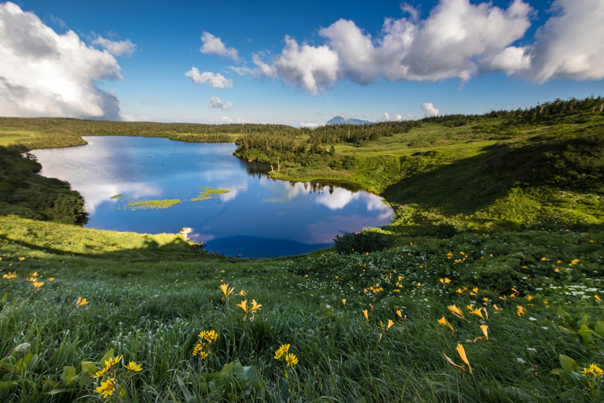
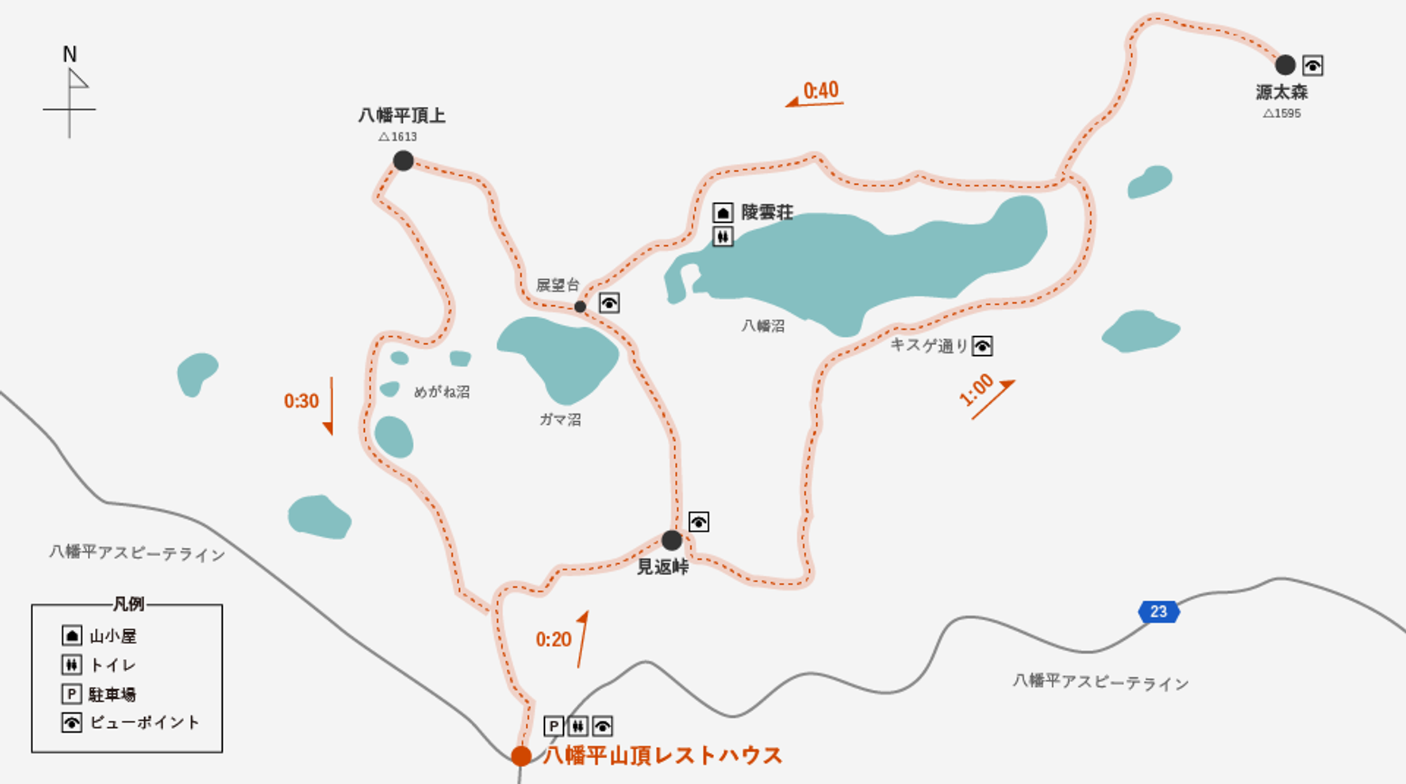
Near the summit of the Hachimantai Aspite Line, where it intersects with the Hachimantai Jukai Line, lies a popular trail that winds through beautiful alpine wetlands surrounding Hachimantai Marsh and Kagami Marsh. The trail is very well-maintained and features boardwalks through the marsh areas.
Along the trail, maps and information about local flora and fauna are posted. There is also a mountain hut with restroom facilities partway along the route. You can adjust the length of your hike by choosing either the longer or shorter hiking trails that pass through this beautiful area. Access is only possible from mid-April to November when the Hachimantai Aspite Line is open. (Please note that snowshoes may be required in early spring.) The flowers blooming along this trail in June are especially popular with locals during this season.
Before ascending the Hachimantai Aspite Line, please stop by the Matsuo Hachimantai Visitor Center near the entrance. There, you can check the current conditions via a live camera near the summit. Right next to it is the "Farm-to-Table Aspite" facility, where we recommend buying a delicious locally produced bento box and eating it on the wooden deck overlooking the pond in the summit area.
The Hachimantai Aspite Line opens on April 15th every year, and the Hachimantai Jukai Line opens on April 26th. (Scheduled)

Course Time

section
Time
Hachimantai Summit Parking Lot → Mikagari Pass
Approximately 20 minutes
Mikawari Pass → Genta Forest
Approximately one hour
Genta Forest → Mount Hachimantai Summit
Approximately 40 minutes
Hachimantai Summit → Hachimantai Summit Parking Lot
Approximately 30 minutes

※Course times and distances are approximate.

Access

section
Transportation Name
Time
Morioka Station - Mount Hachimantai Summit
Iwate Kita Bus
Approximately 2 hours
Lake Tazawa Station - Mount Hachimantai Summit
Ugo Kotsu, Akita Kita Bus
Approximately 2 hours and 20 minutes
※For details, please check with the ticket counters or websites of each transportation provider.

Mt. Mitsuishi

(Level: Intermediate | Duration: 3–4 hours for most people)
Mount Mitsuishi, at an elevation of 1,466 meters, is one of the most popular hikes in the region. The short alpine trees near the summit turn bright orange and red starting around September each year. This is one of the first places to enjoy the colors of autumn.
The trail is well-marked and suitable for children and seniors. This is an ideal option for healthy individuals with little hiking experience.

Course Time

section
Time
Appi Kogen Gondola Summit → Ryōun-sō
5 hours and 25 minutes
Ryōun-sō → Mitsuishi-sansō
8 hours and 50 minutes
Mitsuishi Mountain Lodge → Mount Iwate Eighth Station Emergency Shelter
6 hours and 35 minutes
Iwate-san Eighth Station Shelter → Yakibashiri Trailhead
4 hours and 35 minutes

※Course times and distances are approximate.

Access

section
Transportation Name
Time
To Appi Highlands
private car
20 minutes from Yasuyo IC
To the Yakiashi Trailhead
private car
15 minutes from Nishine IC
※For details, please check with the ticket counters or websites of each transportation provider.

Mount Iwate - Yakiashi Course

(Level: Intermediate | Duration: 6–9 hours depending on pace)
Mount Iwate is the highest peak in Iwate Prefecture and is selected as one of Japan's 100 Famous Mountains. Its smooth eastern slope resembles the shape of Mount Fuji, while the other side forms part of the mountain range extending into Akita Prefecture. Numerous trails lead to the summit, each with its own appeal. The Yakeharashi Course begins adjacent to an area transformed by ancient volcanic eruptions and is covered in volcanic rock. The trail passes through forest, past mountain huts, and ultimately reaches the barren volcanic summit. The best season is said to be late June when flowers bloom along the trail.

Course Time

section
Time
Trailhead → Vent
2 hours up, 1.5 hours down
Spout → Hirakasa Fudo Shelter
2.5 hours to climb, 1.5 hours to descend
Hirakasa Fudo Shelter → Summit
40 minutes uphill, 25 minutes downhill

※Course times and distances are approximate.

Access

section
Transportation Name
Time
Nishine IC → Yakibashiri Trailhead
private car
Approximately 15 minutes
※For details, please check with the ticket counters or websites of each transportation provider.

Mount Iwate - Nanataki Course

(Level: Advanced Length: Very long...6 to 9 hours)
The Nanataki Course is the longest of the standard trails to the summit of Mount Iwate. Its name means "seven waterfalls," and the initial section of the trail actually passes numerous beautiful waterfalls. After climbing through the forest, you pass through thrilling volcanic terrain where sulfur gas erupts from fissures. You then enter alpine forest before finally emerging into the desolate volcanic landscape around the summit. This is a somewhat challenging hike, but it offers great satisfaction and is recommended for experienced hikers (and a favorite of this hiker). Bring a map or at least check one beforehand. There are several branching points along the way.

Course Time

section
Time
Trailhead → Nanataki Viewpoint
40 minutes uphill, 30 minutes downhill
Nanadaki Lookout → Daijigoku Junction
2 hours uphill, 1.5 hours downhill
Great Hell Fork → Summit
Ascent: 3 hours 10 minutes, Descent: 2 hours 30 minutes

※Course times and distances are approximate.

Access

section
Transportation Name
Time
JR Morioka Station → Prefectural Forest Entrance
Iwate Kita Bus, bound for Matsukawa Onsen
Approximately 1 hour and 45 minutes
Matsuo Hachimantai IC → Prefectural Forest Parking Lot
private car
Approximately 30 minutes
※For details, please check with the ticket counters or websites of each transportation provider.

Mount Iwate - Kamibo Course

(Level: Intermediate | Duration: 4–6 hours depending on pace)
The most challenging part of the Kamifuku Course on Mount Iwate is finding the trailhead. It's a short drive from the Yakeharu trailhead, but only a small sign marks the turn, and you must proceed along an unpaved road through a logging area. After that, you'll find a small mountain hut and parking lot indicating the starting point. The hike begins in the forest and eventually joins the Yakeharashi trail. It's essentially a shortcut that saves several hours from the Yakeharashi course, ideal for those short on time or preferring an earlier summit. (There are no restrooms at the trailhead, so it's recommended to rest first at the Yakeharashi rest area.)

Course Time

section
Time
Trailhead → Pickaxe Fork
Ascent: 2 hours 20 minutes Descent: 1 hour 50 minutes
Tsuru-hashi Fork → Hirakasa Fudo Shelter
1 hour to climb, 40 minutes to descend
Hirakasa Fudo Shelter → Summit
40 minutes uphill, 30 minutes downhill

※Course times and distances are approximate.

Access

section
Transportation Name
Time
Nishine IC → Kamifu Trailhead
private car
Approximately 30 minutes
※For details, please check with the ticket counters or websites of each transportation provider.

Gozaishinuma/Goshikinuma Hiking Course

(Level: Beginner | Time Required: 30 minutes to 1 hour)
A short trail leads from the parking lot to Goshikinuma. Literally meaning "Five-Colored Ponds," volcanic minerals feed into the lakes, causing their colors to change with the seasons. In the summer heat, the water turns a vivid deep blue, making the red clay shores stand out sharply. Gozaishinuma Lake is directly adjacent and very beautiful, though it lacks the color changes seen in the neighboring pond. A small observation deck offers views of both ponds, allowing visitors to appreciate the difference.